


Pondera can determine the most efficient wind measurement strategy for your location. We will work with you from the beginning of the project to help determine the wind speed prediction as accurately as possible. We can do this through wind measurements, using methods such as existing measurements from the area, or the SCADA data from existing wind turbines. In addition, we use meteorological measuring masts, LiDAR (wind measurements based on laser beams), or a combination of these resources. It is our firm belief, that by smartly combining existing and new wind measurements, uncertainties in energy yield calculations can generally be significantly reduced.
Pondera works with various different technologies to achieve these reductions. If you want to learn more about the various technologies, see further below.
We offer some of our services in conjuction with Oldbaum Services Ltd., specifically the scanning LiDAR measurements.
Quality assurance
Pondera works brand-independently, and always suggests the most suitable first-class instrumentation for your project. Its campaigns, reporting and calculation results are seen as bankable across the globe and are subject to our ISO9001-certificate. We design campaigns in line with IEC61400-12-1 (2017) and relevant MEASNET guidelines and always work with calibrated instrumentation. For various regions, we work with local partners in the execution of measurement campaigns. Quality monitoring and control is carried out at our Dutch head-offices.
Services
In the realm of wind measurements, we provide the following services:
- Strategy design
- Campaign specification and instrument selection
- LiDAR/instrument verification
- Contracting & purchase support
- Installation monitoring & commissioning (client-rep)
- Remote monitoring
- Data quality control & reporting
- Full meteorological and/or metocean assessment reporting
- Design due diligence
Measurement technologies
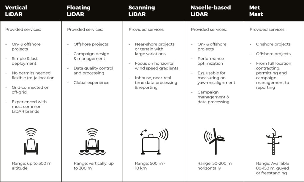
Vertical LiDAR
LiDAR is a measurement device that uses a laser to measure the wind. LiDARs are applied in various different roles, depending on the site and the measurement requirements.
The most common use is that of ground-based, vertical LiDAR. In Pondera’s view LiDAR wind measurements provide reliable data, traceable and flexible in use. In that sense it is similar to the accuracy of MEASNET-calibrated met masts. The great advantage of LiDAR over a mast is that the measuring equipment takes up very little space and is unobtrusive, the installation is not subject to obtaining permits, and it can easily be moved over a (larger or complex) site. The benefit of this is that the wind can be measured in different places within the project area. This offers great advantages compared to measurements made with a single met mast or tower.
Another important advantage of LiDAR measurements is the ability to measure with certainty up to 200m above ground level. For heights above this, measurements become more experimental. Measurements like these allow for wind over the entire rotor area of the wind turbine to be measured.
Pondera has experience with measurement campaigns both onshore and offshore (floating LiDAR). We have a number of LiDARs available for rent, but can also manage your LiDAR for you as part of your project portfolio. In order to achieve the highest accuracy, we recommend regular verification of the used equipment against a proven, IEC-compliant met mast.
Floating LiDAR
Similar to the land-based version, the Floating LiDAR is able to measure wind in a vertical direction and aims to provide crucial site information about your offshore site. Apart from the wind and other meteorological parameters, oceanographic parameters such as wave height, currents, water depth and other factors crucial for design of offshore structures (foundations, scour protection, substation, cabling) can also be measured.
Pondera provides a wide range of services and has knowledge on how to design, contract and execute such a campaign, and works with experts in the fields of modelling and measuring technique to help quality control any floating LiDAR based campaign for you.
Scanning LiDAR
Similar to the vertical version, the Scanning LiDAR is able to measure the wind speed and direction, but it sweeps the scanning head over a range of azimuth angles while the elevation angle is fixed. Scanning LiDAR is specifically useful to determine wind speed and direction gradients over hard-to-reach sites, e.g. near-shore wind farm locations under development. In conjunction with onshore ‘verification’ sources such as a met mast or vertical LiDAR, Scanning LiDAR can be a cost-effective solution where a floating LiDAR campaign is too difficult or too expensive. Pondera can provide you with advice on how to use Scanning LiDAR in your measurement strategy and for execution will collaborate with Oldbaum Services Ltd upon request.
Nacelle-based
Aimed at solving inefficiencies in operations of wind turbines in terms of, for example, suboptimal inflow-angle, nacelle-based LiDAR is an option. Nacelle-based LiDARs can be built-in to existing wind farms where inefficiencies are expected, but they are also designed to be included permanently on locations where fixed, ground-based sources of independent wind speeds for production verification (such as at offshore sites) are impossible.
Pondera can provide you with advice on how to use nacelle-based LiDAR in your measurement strategy and can design and execute measurements if so requested.
Met mast
For some locations, however, the use of a meteorological measuring mast, or ‘met mast’, is more adequate. This applies, for example, to locations where turbulence is expected to be a critical item, but also to projects where long-term measurements are expected, such as the production verification of an existing or yet to be built wind farm. Met masts are also crucial in power curve measurements according to the applicable IEC-standard (IEC61400-12-2).
Pondera can manage the whole met mast ‘process’ for you, in conjunction with local partners. From the location selection and the permit application up to the conceptual design and instrument specification, contracting, the construction guidance and commissioning and the data processing and reporting. The end result: an operational guy-wired met mast or free-standing tower up to a height of 180m.
